
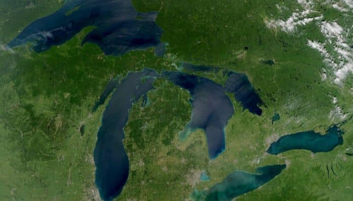
Lake Erie was once Lac du Chat, the “Lake of the Cat.” Lake Huron appeared on a famous 1656 map as Karegnondi, and Lake Michigan was saddled for a time with a name honoring a group the French called the “stinkards.”
The five names used today only settled into place in the 18th century, and a 1744 map is the first to show all five in recognizable form. Before that, the lakes collected a long and confusing list of labels.
How Europeans first reached the lakes
The Great Lakes sit on or near the border between the United States and Canada and formed as huge Ice Age glaciers melted. Indigenous peoples had lived around them for thousands of years before the rest of the world gave them any names at all.
The first Europeans known to see them were French explorers and missionaries who traveled inland along the St. Lawrence River in the early 1600s. Interpreter Étienne Brûlé, who reached Quebec in 1608 and lived among Indigenous communities, is believed to have seen four of the five lakes, missing only Lake Michigan.
His employer, explorer and mapmaker Samuel de Champlain, was the first to write down his own observations of Lakes Huron and Ontario, in a book published in 1619.
The last lakes to be documented
Lake Superior first appears in writing in a 1641 account by the Récollet priests Isaac Jogues and Charles Raymbault. Lake Erie took longer, because the Haudenosaunee, or Iroquois, nations largely kept European explorers away from it until Louis Jolliet reached its shores in 1669.
Jean Nicollet is often called the first European to see Lake Michigan, in the 1630s. Records from the following decade suggest he probably reached Lake Superior instead, and by the 1670s several expeditions had documented trips on Lake Michigan.
Five lakes, many names
Indigenous names, or the names of Indigenous nations, shaped many of the labels the French used. Others were purely French.
- Lake Ontario. French missionaries were using “Ontario” by 1641, from the Wendat word Ontarí:io, meaning “great lake” or “beautiful lake.” It was also Lac St. Louis to Champlain, Lac des Iroquois, Lac Frontenac after the governor general of New France, and Skanadario, a Haudenosaunee word with a similar meaning.
- Lake Erie. The smallest of the five by volume took its name from the Eriehronon, a nation living on its southern shore. A Récollet friar rendered the name as “Cat People,” supposedly because of the wildcats in the area, which produced the alternate name Lac du Chat.
- Lake Huron. Champlain called it La Mer Douce, the “freshwater sea,” and it was also known as Lac d’Orleans. Missionaries named it for the Wendat, whom the French called the Hurons, and Nicolas Sanson’s 1656 map labeled it Karegnondi, said to be a Wendat word for “freshwater sea.”
- Lake Michigan. Champlain simply called it Grand Lac. It then became Lac des Puans, after the Ho-Chunk, or Winnebago, who lived in a foul smelling area on Green Bay, and later Lac des Illinois, Lac St. Joseph and Lac Dauphin. The modern name, said to come from the Ojibwe “michi-gama,” or “great water,” took shape on 1670s maps as Missihiganin and Michigane.
- Lake Superior. The Ojibwe called it gitchi-gami, roughly “big sea.” The French “supérieur” fits the largest lake well, but it originally meant “upper,” marking its position upstream of the others, and the lake was briefly called Lac Tracy after a 1666 French military victory over the Haudenosaunee.
A map that tried to include everything
The confusion shows up clearly on a 1688 map by Venetian cartographer Vincenzo Coronelli. He piled several popular names together, labeling one lake “Lac Frontenac, ou Ontario, et Skaniadorio, ou S. Louis.”
Much of this detail comes from a 1955 journal article by Ivan Walton, a University of Michigan professor and Great Lakes scholar.
When the modern names stuck
The names Superior, Michigan, Huron, Erie and Ontario became standard during the 18th century, though older ones hung on for a while. A 1703 map by French cartographer Guillaume Delisle still called Lake Michigan “Lac des Ilinois,” and a 1733 map by English cartographer Henry Popple showed “Lake Ontario or Frontenac.”
The turning point came in 1744. A map by Jacques Nicolas Bellin, one of the leading cartographers of his day, listed all five names in French forms that anyone today would recognize.
The naming story has not completely ended. In August 2026, according to History.com, President Donald Trump signed an executive order renaming Lake Ontario as Lake America for U.S. government use, while Canada continues to call it Lake Ontario.
Based on reporting by History.com
By Steven Ricks | Geography