
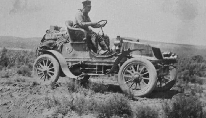
In 1903, a Vermont doctor named H. Nelson Jackson bet $50 that he could drive a car from San Francisco to New York City. He made it, with his mechanic Sewall Crocker and a dog named Bud, but the trip took 63 days.
There were no highways, no gas stations and no motels along the way. Before roads like Route 66 existed, crossing America by car was closer to an expedition than a vacation, and the drivers who tried it helped create the highway network we use today.
A road trip packed like a safari
Route 66 was created in 1926 as part of the new U.S. Numbered Highway System, which was meant to bring interstate roads up to date for the age of the automobile. Before that, the Brooklyn Eagle described a cross-country drive in 1910 as “the last call of the wild.”
Jackson and Crocker loaded their red 1903 Winton with everything they thought they might need. The list included a full set of tools, 150 feet of hemp rope, camping and cooking gear, a fireman’s axe, a shotgun and pistols, extra fuel tanks and exactly one spare tire.
The two men spent weeks stuck waiting for parts and climbed out of more mud holes than anyone could count. Their car is now kept at the National Museum of American History, and the well publicized trip inspired a whole generation of adventurous “automobilists” to try the same thing.
Millions of miles of bad road
At the turn of the 20th century, cars were a rare and expensive luxury. People who wanted to get from one city to another usually took the train.
The only paved roads, mostly brick, were found downtown in large cities. Outside town, country roads were rutted dirt trails used by horse-drawn wagons, and a rainstorm turned them into a sticky mess that locals called “gumbo.”
Cyclists were among the first to push for better roads. In the late 1800s, wealthy bicycle fans backed the Good Roads Movement, which wanted improvements in both cities and the countryside, and some cycling clubs even supported paid subscription bike paths.
Progress was slow. Of the 2.15 million miles of rural road in the country in 1904, only 154,000 miles had any surface at all, and that figure counted loose gravel.
Brian Butko, who wrote a book about the Lincoln Highway, points out that Americans now take government-built highways for granted. Just a few generations ago, he notes, that was not the case at all.
Test yourself
How much have you picked up so far?
3 quick questions on what you have read so far. The story continues below.
Maps drawn by hand
After Jackson's trip, "motor touring" became a popular adventure sport for the rich. Drivers wore goggles because cars did not have windshields yet, and they set off to explore the West and visit national parks such as Yellowstone and Yosemite.
GPS was obviously out of the question, but so were road maps. A 1905 article called "Camping Out with an Automobile" told readers to visit the library, study topographical and survey maps, and trace their own route onto tracing paper.
The same article suggested traveling with two cars of the same make and model so the drivers could swap parts, since breakdowns caused many of the delays. Recommended supplies for a long drive included:
- compasses, thermometers and a hydrometer for testing the quality of gasoline
- rubber ponchos and tire chains
- plenty of guns and ammunition
- blocks and tackle for hauling a stuck car out of the mud
Many rural Americans had never seen a car. One early motorist stopped at a farm to ask for directions and reported that a small boy took one look at the noisy, dusty machine and began to cry.
The Pathfinder maps the routes
By 1912, motor touring had grown from a hobby into a real movement for coast-to-coast highways. The American Automobile Association, formed in 1902, hired a Norwegian immigrant and mapmaker named A. L. Westgard to plot the best cross-country routes.
Westgard already had more than 4,000 miles of scouting behind him, driving a Midland Pathfinder 40 between New York and California. People started calling him "the Pathfinder," and he proposed three main trails for AAA.
The Northwest Trail ran from New York to Chicago and then through Wisconsin, Minnesota, North Dakota and past Yellowstone before ending in Seattle. The Midland Trail covered 3,157 miles from Atlantic City, New Jersey, to San Francisco and then continued down the coast to Los Angeles.
The Overland Trail ran between the other two, heading west from Chicago through Iowa, Nebraska and Wyoming, then southwest through Utah and Nevada to San Francisco. Westgard's routes, along with two later trails across the South, were so well chosen that major highways later followed them, including U.S. Route 40 on the Midland Trail and Interstate 80 on the Overland Trail.
The Lincoln Highway gets America out of the mud
Maps helped, but road conditions were still rough, and neither the federal nor the state governments wanted to spend tax money on interstate roads. Private groups stepped in instead.
In 1913, a group of wealthy Midwestern businessmen founded the Lincoln Highway Association to build the first well marked and well maintained road across the country. The idea came from Carl Fisher, who made his fortune selling car headlamps and helped found the Indianapolis Motor Speedway.
Fisher persuaded friends in the auto industry, among them Goodyear co-founder Frank Seiberling, to pledge millions to the project. Butko says the highway helped their businesses, but he believes the founders also sincerely wanted to "get America out of the mud," as they liked to put it.
The Lincoln Highway stretched 3,000 miles from New York City to San Francisco and largely followed Westgard's Overland Trail. At first the route was marked with red, white and blue paint on utility poles, and in 1928 road crews put up 3,000 concrete markers with brass medallions and arrows.
Drivers had their own tradition, too. According to Butko, travelers, mostly wealthy Easterners, would dip their tires in the Atlantic before leaving and dip them again in the Pacific when they reached San Francisco.
From private trails to federal highways
Other private groups promoted their own routes around the same time. The Yellowstone Trail eventually ran from the East Coast to the Pacific Northwest, and parts of the National Old Trails Road later became Route 66 between New Mexico and California.
In 1915, Westgard wrote about how much had changed in only five years since his first trip across the country. Rough trails, unbridged streams and poor lodging had given way, in his words, to well developed touring routes with bridges, easy grades and dependable cars.
Those privately funded roads paved the way for the U.S. Numbered Highway System in 1926. The Interstate Highway System followed when it was authorized in 1956, more than half a century after Jackson won his $50 bet.
Based on reporting by HISTORY
By Trivia News Staff | Geography